
File:1947 Nanhai Zhudao.png
原始文件 (2,654 × 3,840像素,文件大小:4.42 MB,MIME类型:image/png)
 本媒体文件已于2024年2月13日提交到删除请求。 要讨论存废事宜,请到 删除请求子页面.
请不要移除本模板,直至删除请求完结为止。 删除请求理由: No source link and no license link. On bottom of file is nansha.org.cn - but this
| |||
| |||
摘要
| 描述 |
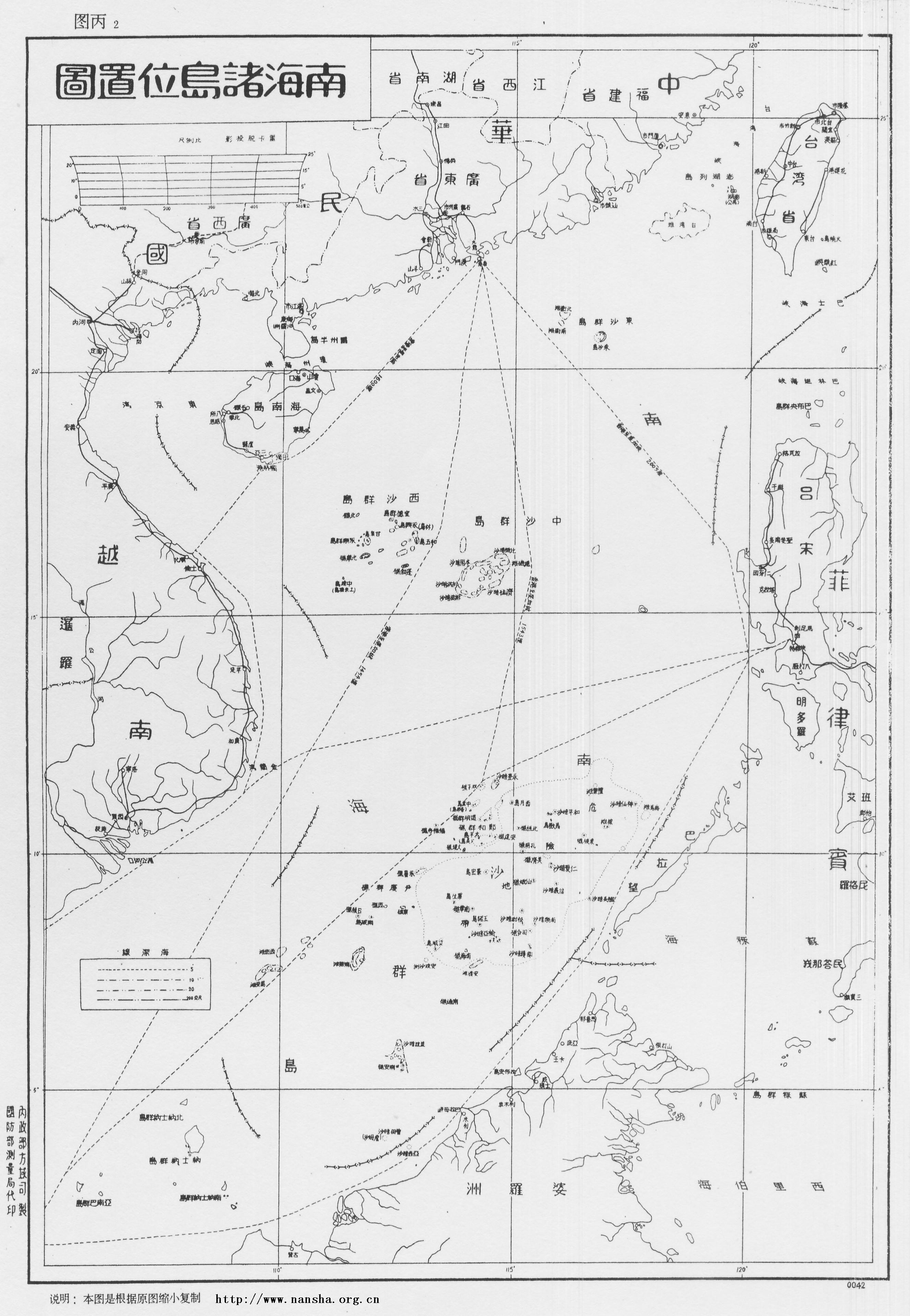
English: Location Map of South China Sea Islands, Secretariat of Government of Guangdong Province. January, 1947.
Left margin written as: Made by Territory Department of Ministry of the Interior, printed by Bereau of Surveying of Ministry of Defence. Now in Sun Yat-sen Library of Guangdong Province, China, this map describes Dongsha Islands, Xisha Islands and Zhongsha Islands in details. Every island has its name in Chinese and English, with depth of sea marks and descriptions as following: "November of 35th year of the Republic (A.D. 1946), Executive Yuan ordered the Navy Command Headquarter and Ministry of the Interior to assist Guangdong government to accept Nanhai Zhudao: ROCS Taiping, ROCS Zhongye to accept Tuansha Qundao, ROCS Yongxing, ROCS Zhongjian to accept Xisha Qundao. The mission is completed in December of the same year. In honor of the actions of Taiping Ship and Yongxing ship, Chang Island (長島) is renamed to Taiping Island (太平島), and the Lin Island (林島) is renamed to Yongxing Island (永興島) under orders. The Xiniao Island (西鳥島) is also called Spratly Island. Because it is located in the far south, so the Goverment renames it to Nanwei Island (南威島). The Ministry of the Interior adjusted the names of the islands according to their locations in the South China Sea, so changed Tuansha Islands (團沙群島) (i.e. Xinnan Islands (新南群島) by Japanese, Spratly Islands by Westerners) to Nansha Islands (南沙群島), and the former Japanese Nansha Islands (南沙群島) is renamed to Zhongsha Islands (中沙群島). The other islands and reefs are named after the historical diplomats to the Nanyang, in memory of them."中文:《南海諸島位置圖》1947年正月广东省政府秘书处编制。左侧写明:内政部方域司制,国防部测量局代印。现藏于广东省立中山图书馆。
图中详绘了东沙群岛、西沙群岛、中沙群岛,各岛屿有中英对照,海标均有深度,并附有说明: “中华民国三十五年十一月,行政院令海军总司令部、内政部协助广东省政府接收南海诸岛,并派太平舰、中业舰接收团沙群岛,永兴舰、中建舰接收西沙群岛, 同年十二月任务完成,为纪念太平舰、永兴舰之行之盛举,奉命将长岛改名为太平岛,林岛改名为永兴岛。本府以西鸟岛又名斯巴特列岛,远处南疆,特改为南威岛。 内政部为调整各群岛名称,复将团沙群岛(即日人所称之“新南群岛”,西人所称之Spratly群岛)改为南沙群岛,原曰之南沙群岛则改为中沙群岛, 以符诸岛在南海所处之位置。其余各岛洲礁多以历朝出任南洋使节之名以名之,以志纪念焉。” |
| 日期 | |
| 来源 |
Made by Territory Department of Ministry of the Interior, printed by Bereau of Surveying of Ministry of Defence. Now in Sun Yat-sen Library of Guangdong Province, China, this map describes Dongsha Islands, Xisha Islands and Zhongsha Islands in details. Every island has its name in Chinese and English, with depth of sea marks and descriptions as following: |
| 作者 | Secretariat of Government of Guangdong Province, Republic of China |
本图像目前因在中国著作权保护条款过期而处于公有领域。
根据中华人民共和国(司法管辖区为中国大陆,不包括香港和澳门)的著作权法,法人或者非法人组织的作品,职务作品及所有视听作品,首次发表50年后或自创作之日起50年未发表,进入公有领域;著作权保护期于2021年6月1日前届满的自然人摄影作品,属于公有领域;其他自然人作品,则在作者死亡后50年后进入公有领域。 根据中华民国(目前司法管辖区为台澎金马地区)的著作权法,所有摄影作品,以及所有著作权持有者为法人的作品,在首次发表50年后,或者从创作之日起50年未发表,即进入公有领域。其他适用作品则在作者死亡后50年进入公有领域。 重要提醒:来自美国以外国家的作品必须在其母国和美国不受版权保护或有自由授权,才可以上传至维基共享资源。来自中国,并在美国基于特定条件(例如在不遵守美国版权程序的情况下发表)进入公有领域的作品,如果在其来源国的URAA生效日期受版权保护的话(根据美国版权署记载,对于中华人民共和国为1996年1月1日,对于中华民国(台湾)则为2002年1月1日),那么其美国版权可能根据乌拉圭回合协议法案(URAA)而获回溯致上传者:请提供该图像的首次发表时间及其作者或著作权持有者姓名。
|
  |
本作品在美国属于公有领域,是因为符合下列三个条件:
关于其背景信息,参见非美国版权之解释。
注意:这个标签不应用于录音作品。 |
文件历史
点击某个日期/时间查看对应时刻的文件。
| 日期/时间 | 缩略图 | 大小 | 用户 | 备注 | |
|---|---|---|---|---|---|
| 当前 | 2008年5月6日 (二) 11:52 | | 2,654 × 3,840(4.42 MB) | Shibo77 | 说明:1947 《南中国海图》1947年正月广东省政府秘书处编制。 图中详绘了东沙群岛、西沙群岛、中沙群岛,各岛屿有中英对照,海标均有深度,并附有说明。 中华民国三十五年十一月,行政院� |
文件用途
以下页面使用本文件:
全域文件用途
以下其他wiki使用此文件:
- en.wikipedia.org上的用途
- Spratly Islands
- South China Sea Islands
- Scarborough Shoal
- Spratly Islands dispute
- Nine-dash line
- South China Sea Arbitration
- Template:Did you know nominations/Philippines v. China
- Wikipedia:Featured picture candidates/March-2014
- Wikipedia:Featured picture candidates/1947 Nanhai Zhudao
- 2016 in the Philippines
- Timeline of the South China Sea dispute
- en.wiktionary.org上的用途
- fr.wikipedia.org上的用途
- fr.wiktionary.org上的用途
- id.wikipedia.org上的用途
- incubator.wikimedia.org上的用途
- it.wikipedia.org上的用途
- ja.wikipedia.org上的用途
- ko.wikipedia.org上的用途
- no.wikipedia.org上的用途
- pl.wikipedia.org上的用途
- tl.wikipedia.org上的用途
- vi.wikipedia.org上的用途
- vi.wiktionary.org上的用途
- zh.wikipedia.org上的用途
- zh.wikivoyage.org上的用途