
File:9 dotted line.png

本预览的尺寸:487 × 600像素。 其他分辨率:195 × 240像素 | 390 × 480像素 | 979 × 1,206像素。
原始文件 (979 × 1,206像素,文件大小:1.79 MB,MIME类型:image/png)
摘要
| 描述 |
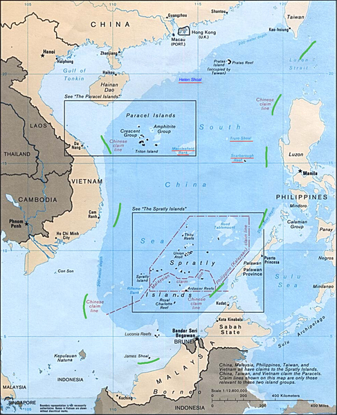
English: Map of the South China Sea, with 9-dotted line highlighted in green |
| 日期 | |
| 来源 | Asia Maps — Perry-Castañeda Map Collection: South China Sea (Islands) 1988 |
| 作者 | U.S. Central Intelligence Agency |
| 其他版本 | file:Schina_sea_88.png |
许可协议
| 本图像是中央情报局雇员的职务作品。作为美国联邦政府的作品,本图像或媒体属于公有领域。
|

|
原始上传日志
原始描述頁面位於這裡。下列使用者名稱均來自en.wikipedia。
- 2011-10-20 18:05 JasonAQuest 979×1206× (1880133 bytes) {{Information |Description=Map of the South China Sea, with 9-dotted line highlighted in green |Source=[http://www.lib.utexas.edu/maps/asia.html Asia Maps — Perry-Castañeda Map Collection]: South China Sea (Islands) 1988 |Date=1988 |Author=U.S. Central Intelligence Agency |Permission={{PD-USGov-CIA}} |other_versions=Schina sea 88.png }} [[Category:South China Sea]] [[Category:Spratly Islands]] [[Category:Paracel Islands]]
文件历史
点击某个日期/时间查看对应时刻的文件。
| 日期/时间 | 缩略图 | 大小 | 用户 | 备注 | |
|---|---|---|---|---|---|
| 当前 | 2011年10月21日 (五) 22:29 | | 979 × 1,206(1.79 MB) | Cantons-de-l'Est | {{Information |Description={{en|Map of the South China Sea, with 9-dotted line highlighted in green<br/> en:Category:South China Sea en:Category:Spratly Islands en:Category:Paracel Islands}} |Source=Transferred from [http://en.wikipedia. |
文件用途
以下页面使用本文件:
全域文件用途
以下其他wiki使用此文件:
- ar.wikipedia.org上的用途
- az.wikipedia.org上的用途
- ca.wikipedia.org上的用途
- cs.wikipedia.org上的用途
- de.wikipedia.org上的用途
- en.wikipedia.org上的用途
- es.wikipedia.org上的用途
- it.wikipedia.org上的用途
- ja.wikipedia.org上的用途
- ko.wikipedia.org上的用途
- no.wikipedia.org上的用途
- pl.wikipedia.org上的用途
- pt.wikipedia.org上的用途
- ru.wikipedia.org上的用途
- sv.wikipedia.org上的用途
- ta.wikipedia.org上的用途
- th.wikipedia.org上的用途
- tr.wikipedia.org上的用途
- uk.wikipedia.org上的用途
- www.wikidata.org上的用途
- zh.wikipedia.org上的用途