
File:Hawaje-NoRedLine.jpg

原始檔案 (3,600 × 2,800 像素,檔案大小:2.81 MB,MIME 類型:image/jpeg)
摘要
| 描述 |
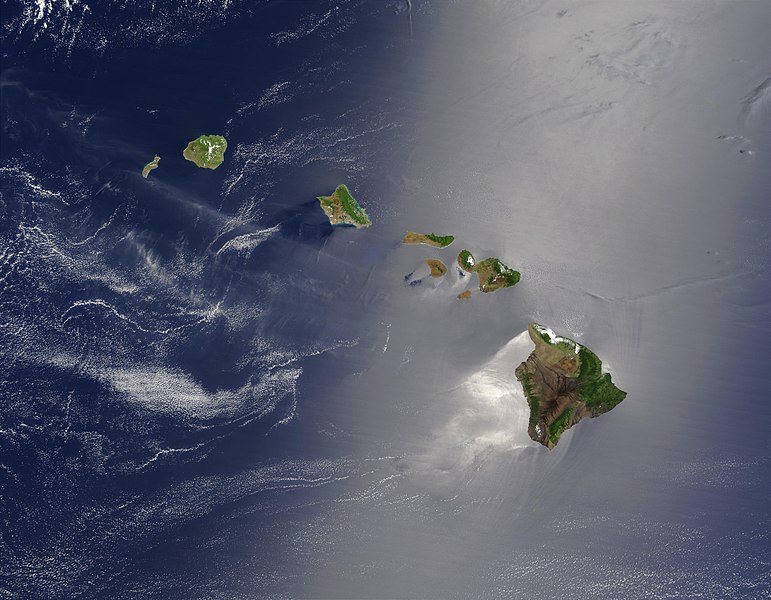
Čeština: Satelitní pohled na Havajské ostrovy
English: Satellite view of Hawaii archipelago (USA) Original description from NASA:
Français : Vue satellite de l'archipel d'Hawaï (États-Unis) |
| 日期 | |
| 來源 |
|
| 作者 | Jacques Descloitres |
| 其他版本 |
 |
| 這是一張修飾過的圖片,即本圖片是用軟體修改過後的版本,修改的方式或內容有:cloned out and healed little red line on the big island。原版圖片來源:Hawaje.jpg。修改者:IdLoveOne。
|
授權條款
| 本作品由NASA創作,屬於公有領域。根據NASA的版權政策:“NASA的創作除非另有聲明否則不受版權保護。”(參見:Template:PD-USGov/zh,NASA版權政策或JPL圖像使用政策) | ||
 |
警告:
|
原始上傳日誌
本檔案衍生自: Hawaje.jpg
- File:Hawaje.jpg licensed with PD-USGov-NASA
- 2005-10-26T18:19:43Z Palladinus 3600x2800 (1211908 Bytes) Hawaii Islands
Uploaded with derivativeFX
評價
|
This image was selected as picture of the day on Wikimedia Commons for 16 June 2011. It was captioned as follows: Other languages:
Čeština: Satelitní pohled na Havajské ostrovy Eesti: Hawaii saared satelliidifotol. Magyar: Hawaii szigetvilágának műholdas képe Português: Texto de cabeçalho. Русский: Спутниковая фотография Гавайских островов 한국어: 하와이 제도의 위성 사진. 日本語: ハワイ諸島の衛星写真 中文: 美国夏威夷的卫星照片 |
檔案歷史
點選日期/時間以檢視該時間的檔案版本。
| 日期/時間 | 縮圖 | 尺寸 | 用戶 | 備註 | |
|---|---|---|---|---|---|
| 目前 | 2010年9月1日 (三) 22:24 | | 3,600 × 2,800(2.81 MB) | IdLoveOne~commonswiki | {{RetouchedPicture|cloned out and healed little red line on the big island|editor=IdLoveOne|orig=Hawaje.jpg}} {{self|PD-USGov-NASA}} == {{Original upload log}} == This image is a derivative work of the following images: *File:Hawaje.jpg licensed w |
檔案用途
下列頁面有用到此檔案:
全域檔案使用狀況
以下其他 wiki 使用了這個檔案:
- ace.wikipedia.org 的使用狀況
- af.wikipedia.org 的使用狀況
- als.wikipedia.org 的使用狀況
- ar.wikipedia.org 的使用狀況
- ary.wikipedia.org 的使用狀況
- arz.wikipedia.org 的使用狀況
- ast.wikipedia.org 的使用狀況
- azb.wikipedia.org 的使用狀況
- az.wikipedia.org 的使用狀況
- ba.wikipedia.org 的使用狀況
- be-tarask.wikipedia.org 的使用狀況
- bh.wikipedia.org 的使用狀況
- bn.wikipedia.org 的使用狀況
- bn.wikibooks.org 的使用狀況
- ca.wikipedia.org 的使用狀況
- ceb.wikipedia.org 的使用狀況
- crh.wikipedia.org 的使用狀況
- cs.wikipedia.org 的使用狀況
- cv.wikipedia.org 的使用狀況
- cy.wikipedia.org 的使用狀況
- dag.wikipedia.org 的使用狀況
- de.wikipedia.org 的使用狀況
- diq.wikipedia.org 的使用狀況
- el.wikipedia.org 的使用狀況
- en.wikipedia.org 的使用狀況
檢視此檔案的更多全域使用狀況。