
File:Political Regions of Sudan - July 2006.svg

此 SVG 檔案的 PNG 預覽的大小:511 × 600 像素。 其他解析度:204 × 240 像素 | 409 × 480 像素 | 654 × 768 像素 | 873 × 1,024 像素 | 1,745 × 2,048 像素 | 600 × 704 像素。
原始檔案 (SVG 檔案,表面大小:600 × 704 像素,檔案大小:647 KB)
| 描述 |
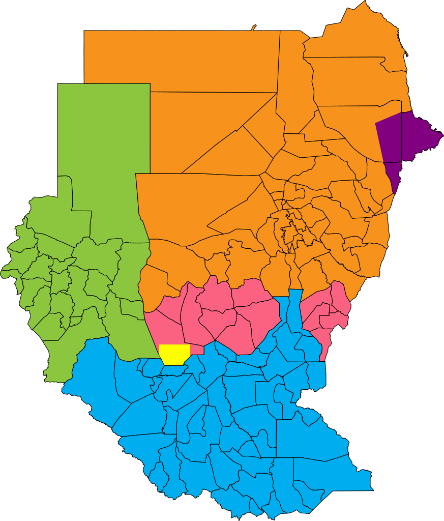
English: Map showing political regions of Sudan as of July 2006.
Darfur
Nuba Mountains and Blue Nile
North Sudan
South Sudan
Eastern Front, area of operations July 2006
Abyei, as defined by the Permanent Court of Arbitration |
| 日期 | |
| 來源 |
|
| 作者 | Lokal_Profil |
| 授權許可 (重用此檔案) |
此檔案採用創用CC 姓名標示-相同方式分享 2.5 通用版授權條款。 姓名標示: Lokal_Profil
|
.png)
檔案歷史
點選日期/時間以檢視該時間的檔案版本。
| 日期/時間 | 縮圖 | 尺寸 | 使用者 | 備註 | |
|---|---|---|---|---|---|
| 目前 | 2011年1月22日 (六) 09:38 | | 600 × 704(647 KB) | Wiz9999 | Updated borders of Southern Kordofan/Nuba Mountains State as according to http://www.occasionalwitness.com/Articles/20040526b.htm and File:Sudan location map.svg |
| 2009年7月26日 (日) 06:42 |  | 600 × 704(640 KB) | Wiz9999 | The Permanent Court of Arbitration has defined new boundaries for Abyei, which both parties have accepted. Official map: [http://www.pca-cpa.org/upload/files/Abyei%20Award%20Appendix%202.pdf] | |
| 2008年5月26日 (一) 19:24 |  | 600 × 704(633 KB) | Lokal Profil | Last two features | |
| 2008年5月26日 (一) 18:57 |  | 600 × 704(581 KB) | Lokal Profil | {{Information |Description={{en|Map showing political regions of Sudan as of July 2006.}} {{legend|#8cc63f|Darfur}} {{legend|#fb6282|Nuba Mountains and Blue Nile}} {{legend|#f7931d|North Sudan}} {{legend|#00adef|South Sudan}} |Source=*Vector map from [[:I |
檔案用途
下列頁面有用到此檔案:
全域檔案使用狀況
以下其他 wiki 使用了這個檔案:
- af.wikipedia.org 的使用狀況
- ar.wikipedia.org 的使用狀況
- arz.wikipedia.org 的使用狀況
- ast.wikipedia.org 的使用狀況
- ba.wikipedia.org 的使用狀況
- bn.wikipedia.org 的使用狀況
- bs.wikipedia.org 的使用狀況
- ca.wikipedia.org 的使用狀況
- cs.wikipedia.org 的使用狀況
- da.wikipedia.org 的使用狀況
- de.wikipedia.org 的使用狀況
- din.wikipedia.org 的使用狀況
- el.wikipedia.org 的使用狀況
- en.wikipedia.org 的使用狀況
- es.wikipedia.org 的使用狀況
- et.wikipedia.org 的使用狀況
- fa.wikipedia.org 的使用狀況
- fi.wikipedia.org 的使用狀況
- fr.wikipedia.org 的使用狀況
- he.wikipedia.org 的使用狀況
- hu.wikipedia.org 的使用狀況
- hy.wikipedia.org 的使用狀況
- id.wikipedia.org 的使用狀況
- it.wikipedia.org 的使用狀況
- ja.wikipedia.org 的使用狀況
- ka.wikipedia.org 的使用狀況
- lt.wikipedia.org 的使用狀況
- nn.wikipedia.org 的使用狀況
- no.wikipedia.org 的使用狀況
- pl.wikipedia.org 的使用狀況
檢視此檔案的更多全域使用狀況。