
File:Border USA Mexico.jpg

預覽大小:800 × 550 像素。 其他解析度:320 × 220 像素 | 640 × 440 像素 | 1,024 × 704 像素 | 1,280 × 880 像素 | 2,560 × 1,760 像素 | 3,600 × 2,475 像素。
原始檔案 (3,600 × 2,475 像素,檔案大小:6.69 MB,MIME 類型:image/jpeg)
摘要
| 描述 |
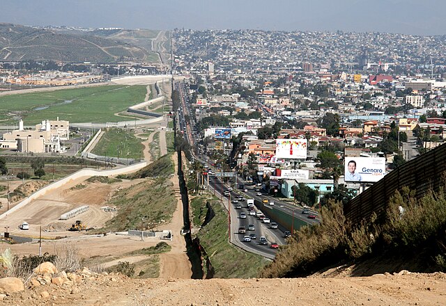
English: A small fence separates densely-populated Tijuana, Mexico, right, from the United States in the Border Patrol's San Diego Sector. Construction is underway to extend a secondary fence over the top of this hill and eventually to the Pacific Ocean.
Español: Una cerca pequeña separa Tijuana, México densamente poblada, a la derecha, de Estados Unidos en el Sector de San Diego de la Patrulla Fronteriza. Se construye una cerca secundaria que irá encima de esta colina y al fin seguirá al océano Pacífico.
Deutsch: Ein kleiner Zaun trennt das dicht bevölkerte Tijuana in Mexiko, im Bild auf der rechten Seite zu sehen, von den Vereinigte Staaten von Amerika in der Region um San Diego. Der Grenzschutz mit weiteren Zäunen wird bis zum Pazifischer Ozean ausgebaut.
Português: Um muro baixo separa a densamente povoada cidade de Tijuana, no México, à direita, dos Estados Unidos no sector fronteiriço de São Diego. Está em curso a construção de uma vedação secundária que se estenderá do cimo da colina e que deverá estender-se até ao Oceano Pacífico.
Français : Une petite clôture sépare le populeux Tijuana (Mexique) à droite, des États-Unis, dans le secteur de San Diego de l'United States Border Patrol. La construction est en cours afin de rallonger une clôture secondaire par-dessus cette colline et finalement à l'océan Pacifique.
Suomi: Yhdysvaltain ja Meksikon välinen raja. Kuvassa vasemmalla Yhdysvaltain Kaliforniaa ja oikealla Meksikon Tijuanaa.
Русский: Небольшой забор в центре фотографии разделяет густонаселённый мексиканский город Тихуана, расположенный справа, и американский город Сан-Диего, расположенный слева. |
| 日期 | |
| 來源 | http://www.ngb.army.mil |
| 作者 | Sgt. 1st Class Gordon Hyde |
| 拍攝地點 | | 位於此地的本圖片與其他圖片: OpenStreetMap |
|---|
授權條款
|
|
 |
評價
|
This image was selected as picture of the day on Vietnamese Wikipedia.
|
| 註解 | 該圖片含有註解:在維基媒體共享資源上查看註解 |
檔案歷史
點選日期/時間以檢視該時間的檔案版本。
| 日期/時間 | 縮圖 | 尺寸 | 使用者 | 備註 | |
|---|---|---|---|---|---|
| 目前 | 2007年8月24日 (五) 00:01 | | 3,600 × 2,475(6.69 MB) | Wikifreund | {{Information |Description=A small fence separates densely populated Tijuana, Mexico, right, from the United States in the Border Patrol's San Diego Sector. Construction is underway to extend a secondary fence over the top of this hill and eventually to t |
檔案用途
下列頁面有用到此檔案:
全域檔案使用狀況
以下其他 wiki 使用了這個檔案:
- af.wikipedia.org 的使用狀況
- ar.wikipedia.org 的使用狀況
- arz.wikipedia.org 的使用狀況
- ast.wikipedia.org 的使用狀況
- ba.wikipedia.org 的使用狀況
- ca.wikipedia.org 的使用狀況
- ceb.wikipedia.org 的使用狀況
- cs.wikipedia.org 的使用狀況
- de.wikipedia.org 的使用狀況
- San Diego
- Tijuana
- San Diego County
- Grenze zwischen den Vereinigten Staaten und Mexiko
- Mexiko
- Portal:Mauern und Grenzen
- Benutzer:WA1TF0R/Galerie
- Tijuana-Kartell
- Wikipedia:Café/Archiv 2015 Q2
- Rassismus in den Vereinigten Staaten
- Wikipedia:Café/Archiv 2016 Q4
- Diskussion:Andreas Scheuer/Archiv
- El Salón México
- Wikipedia:Auskunft/Archiv/2019/Woche 22
- de.wiktionary.org 的使用狀況
- en.wikipedia.org 的使用狀況
- Mexico–United States border wall
- Mexico–United States border
- Talk:Mexico–United States border
- United States
- Mexico
- Metropolitan areas of Mexico
- San Diego–Tijuana
- Wikipedia:Featured pictures/Places/Others
- Wikipedia:WikiProject United States/Recognized content
- San Diego County, California
- Wikipedia:WikiProject United States/Quality content
- Wikipedia:Featured pictures thumbs/29
- Wikipedia:Featured picture candidates/Border Mexico USA.jpg
- Wikipedia:Featured picture candidates/January-2012
- Wikipedia:Wikipedia Signpost/2012-01-16/Featured content
- Global apartheid
- User talk:Morogris/Archive 1
- Wikipedia:Picture of the day/April 2013
- Template:POTD/2013-04-15
- Wikipedia:Main Page history/2013 April 15
檢視此檔案的更多全域使用狀況。