
File:STS066-89-69 - Image of Taiwan Northern Half.jpg

預覽大小:600 × 600 像素。 其他解析度:240 × 240 像素 | 480 × 480 像素 | 768 × 768 像素 | 1,024 × 1,024 像素 | 2,048 × 2,048 像素 | 5,294 × 5,294 像素。
原始檔案 (5,294 × 5,294 像素,檔案大小:5.68 MB,MIME 類型:image/jpeg)
摘要
| 描述 |
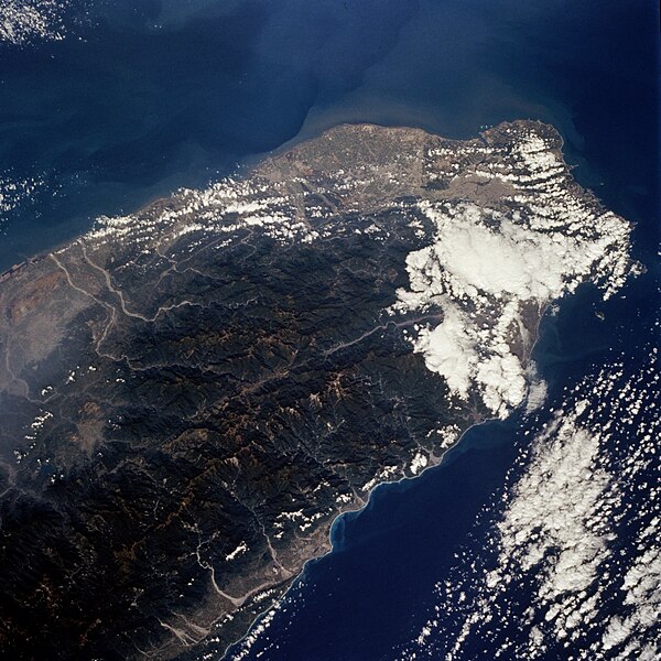
English: The island of Taiwan (National Republic of China) has a population of more than 21 million in an area the size of Switzerland; this photograph shows the northern half of the island. Most of the inhabitants live along the plains that extend along the entire west coast. Ti-pei, the capital with a population of almost 3 million, is located near the northern tip of the island. The small scale of the photograph and the gross resolution allow only identification of the general location of the urban area at the northern end of the island. Many short rivers that drain east and west arise in the Chungyang Mountains that extend for almost the entire length of the country. The mountains of Taiwan, with some of the central ranges rising to altitudes of more than 10 000 feet (3000 meters), are young and still actively undergoing tectonic movement. Taiwan is bordered on the west by the Taiwan Strait, which separates the country from mainland China (People Republic of China), and on the east by the Pacific Ocean. Taiwan is an amazing economic success story; along with Japan, Hong Kong, South Korea, and Singapore, it is considered to be one of the "Pacific Rim Economic Tigers." |
| 日期 | |
| 來源 | JSC Gateway to Astronaut Photography of Earth |
| 作者 | Earth Science and Remote Sensing Unit, 林頓·詹森太空中心 |
| Mission | STS066 |
| Roll | 89 |
| Frame | 69 |
| Geographic area | North Half of Taiwan |
| Features | Mountains, cities, rivers, haze |
| Cloud percentage | 30% |
| Altitude | 162 nautical miles (300 km) |
| Look angle | 25° |
| Look direction | NW |
| Sun Azimuth | 154° |
| Sun Elevation | 47° |
| Camera | Hasselblad |
| Film | 5046: Kodak, natural color positive, Lumiere 100/5046, ASA 100, standard base |
| Focal length | 100 |
| 拍攝地點 | | 位於此地的本圖片與其他圖片: OpenStreetMap |
|---|
| 目標地點 | | 位於此地的本圖片與其他圖片: OpenStreetMap |
|---|
本圖像或影音收錄於美國國家航空暨太空總署 (NASA)休士頓太空中心(Johnson Space Center),其照片編號為: STS066-89-69 此標籤不表示文件的著作權狀態。任何文件在附有此標籤的同時還需要一個有效的著作權標籤。請參閱許可協議說明頁面以了解更多資訊。 其他語言:
|
授權條款
| 本作品由NASA創作,屬於公有領域。根據NASA的版權政策:“NASA的創作除非另有聲明否則不受版權保護。”(參見:Template:PD-USGov/zh,NASA版權政策或JPL圖像使用政策) | ||
 |
警告:
|
檔案歷史
點選日期/時間以檢視該時間的檔案版本。
| 日期/時間 | 縮圖 | 尺寸 | 使用者 | 備註 | |
|---|---|---|---|---|---|
| 目前 | 2024年2月20日 (二) 10:58 | | 5,294 × 5,294(5.68 MB) | Askeuhd | Improved quality and resolution |
| 2004年11月15日 (一) 07:23 |  | 640 × 640(144 KB) | Wdshu | {{PD-USGov-NASA}} |
檔案用途
下列頁面有用到此檔案:
全域檔案使用狀況
以下其他 wiki 使用了這個檔案:
- zh.wikibooks.org 的使用狀況