
File:China Xinjiang.svg

此 SVG 檔案的 PNG 預覽的大小:705 × 599 像素。 其他解析度:282 × 240 像素 | 565 × 480 像素 | 904 × 768 像素 | 1,205 × 1,024 像素 | 2,409 × 2,048 像素 | 1,000 × 850 像素。
原始檔案 (SVG 檔案,表面大小:1,000 × 850 像素,檔案大小:212 KB)
摘要
| 描述 |
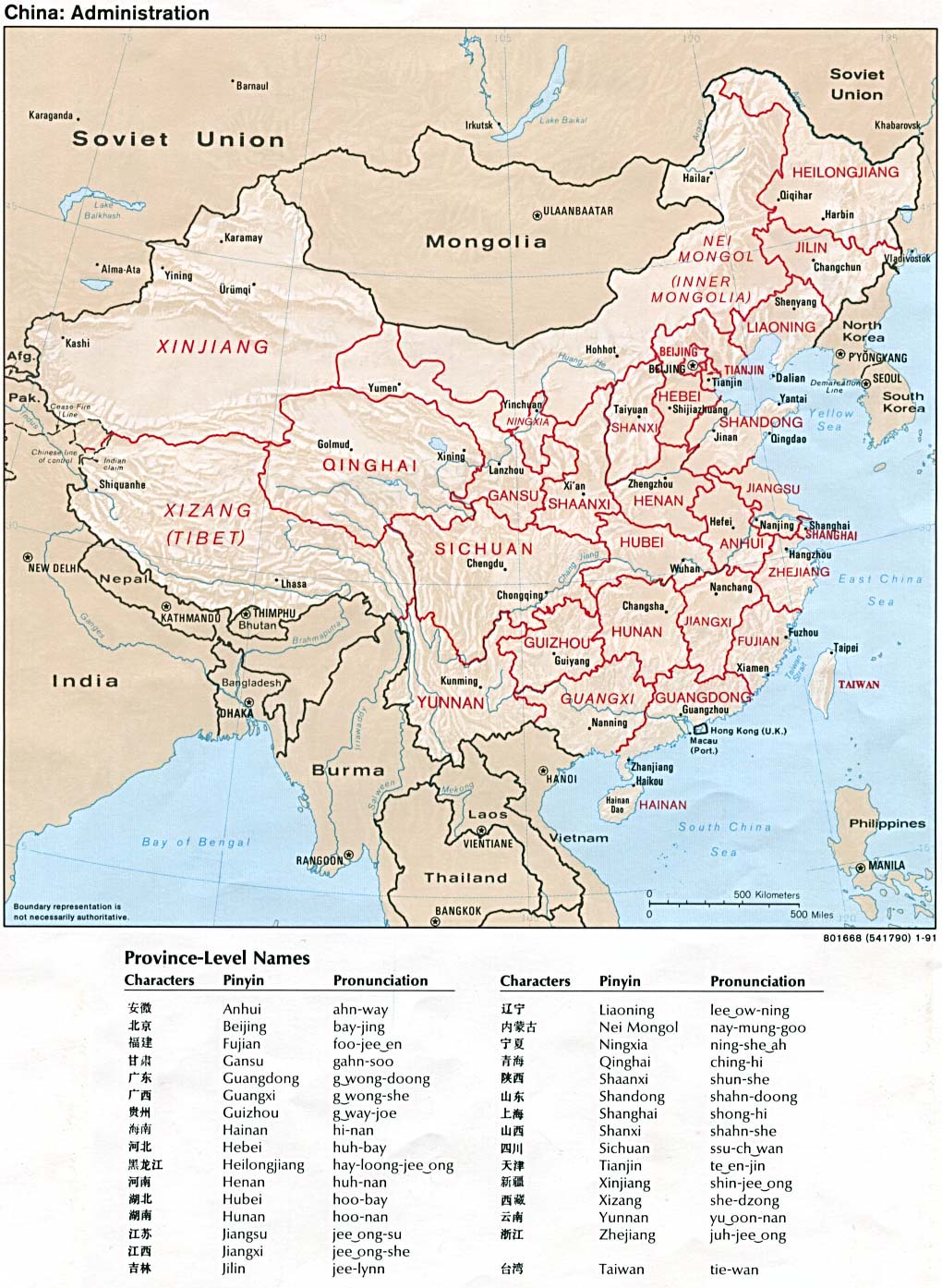
English: An SVG map of China with the Xinjiang autonomous region highlighted
Legend: |
||
| 日期 | |||
| 來源 |
self-made; based on CIA public domain maps: |
||
| 作者 | Joowwww | ||
| 授權許可 (重用此檔案) |
|
||
| 其他版本 |
|

檔案歷史
點選日期/時間以檢視該時間的檔案版本。
| 日期/時間 | 縮圖 | 尺寸 | 使用者 | 備註 | |
|---|---|---|---|---|---|
| 目前 | 2008年8月13日 (三) 16:33 | | 1,000 × 850(212 KB) | Joowwww | added missing laos/vietnam border |
| 2008年5月14日 (三) 11:24 |  | 1,000 × 850(211 KB) | Joowwww | {{Information |Description=An SVG map of China with the Xinjiang autonomous region highlighted Legend:<br />Image:China map legend.png |Source=self-made; based on CIA public domain maps: *http://www.lib.utexas.edu/maps/middle_east_and_asia/china_admi |
檔案用途
下列8個頁面有用到此檔案:
全域檔案使用狀況
以下其他 wiki 使用了這個檔案:
- ar.wikipedia.org 的使用狀況
- az.wikipedia.org 的使用狀況
- bg.wikipedia.org 的使用狀況
- bn.wikipedia.org 的使用狀況
- bs.wikipedia.org 的使用狀況
- cdo.wikipedia.org 的使用狀況
- ce.wikipedia.org 的使用狀況
- cs.wikipedia.org 的使用狀況
- de.wikipedia.org 的使用狀況
- de.wikinews.org 的使用狀況
- en.wikipedia.org 的使用狀況
- en.wikinews.org 的使用狀況
- eo.wikipedia.org 的使用狀況
- es.wikipedia.org 的使用狀況
- eu.wikipedia.org 的使用狀況
- Ürümqi
- Altay prefektura
- Tacheng prefektura
- Turpan prefektura
- Kumul prefektura
- Kashgar prefektura
- Aksu prefektura
- Hotan prefektura
- Börtala Mongoliar Prefektura autonomoa
- Karamay
- Changji Hui Prefektura autonomoa
- Bayin'gholin Mongoliar Prefektura autonomoa
- Shihezi
- Wujiaqu
- Tumshuke
- Aral (Xinjiang)
- Kizilsu Kirgizistar Prefektura autonomoa
- Txantiloi:Xinjiang
- fr.wikipedia.org 的使用狀況
- fr.wikivoyage.org 的使用狀況
- fy.wikipedia.org 的使用狀況
- gan.wikipedia.org 的使用狀況
- hak.wikipedia.org 的使用狀況
檢視此檔案的更多全域使用狀況。